

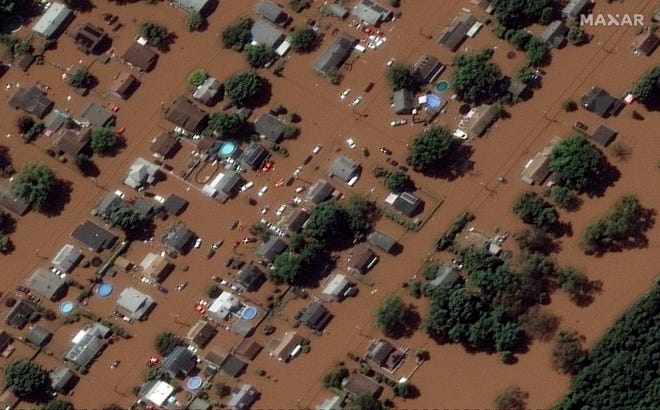
MANVILLE – A year later the remnants of Hurricane Ida brought record floodingThe county continues to take steps to reduce the likelihood of this happening again.
American Water has awarded a $10,000 grant to a reforestation project in the Royce Brook floodplain, the Borough Council is considering an ordinance to update floodplain regulations, and the Borough Council is backing a proposed state law that would require real estate sellers and landlords to notify buyers and tenants if the land is in danger of flooding.
Somerset County Emergency Management received the grant from the utility in partnership with the Rutgers Water Resources Program, Somerset County Office of Planning and Engineering and Somerset County Parks and Recreation.
About 160 trees and 120 shrubs will be planted by volunteers in the Royce Brook floodplain along Raritan Avenue and Whalen Street directly across from Weston Elementary School. The flood from Ida caused countless trees to be uprooted and destroyed in the area.
The site was chosen because it ties in with the Memorial Park Rain Garden Project, which was installed by the Rutgers Water Resources Program in 2020.
The reforestation project joins a $250,000 Somerset County Recreational Open Space grant awarded to Mannville in 2021 to upgrade Lincoln Park in the Lost Valley area.
A significant portion of this grant was earmarked for the removal of impervious surfaces so that rainwater soaks into the ground rather than draining into local waterways.
“Stormwater knows no municipal boundaries, and we’re thrilled to have so many partners in this and other projects to address flood mitigation at the regional level,” said Somerset County Commissioner Doug Singletary, County Emergency Management Liaison Somerset. Management said in a statement: “Through the collaborative planning and implementation of this reforestation project, Somerset County continues its efforts to mitigate the growing threat of flooding to our communities.”
Also see:Mary, environmentalists to Gov. Phil Murphy: Strengthening New Jersey’s flood rules
The county board introduced an updated floodplain ordinance because the current ordinance only governs the development of the Federal Emergency Management Agency’s 100-year floodplain map.
Because the Ida flood exceeded the FEMA flood map by three feet, the new ordinance defines the “true” floodplain, not just the 100-year flood lines, FEMA’s minimum requirement. The ordinance was approved by the state Department of Environmental Protection’s Flood Engineering Team.
The county board also approved a bill introduced in the state Senate that would require prospective property buyers or renters to receive a flood hazard notice before they sign a contract or lease.
The bill would require the state Department of Community Affairs to create a form to tell buyers or renters if a property is in a flood plain, flood hazard or flood risk area, or has ever been affected by a flood.
Email: mdeak@mycentraljersey.com
Mike Dyck is a reporter for mycentraljersey.com. For unlimited access to his articles about Somerset and Hunterdon Counties, sign up or activate your digital account.
